|
|
|||||||||||||||||
| Point ID: 6679 | Downloads | Plots | Site Data | Code: 10062 |
|
|
|||||||||||||||||
| Download | |
|---|---|
| Site Descriptor Information | Site Time Series Data |
| Link to all available data | |
| View: | Time Series | All |
| Units: | m3/s |
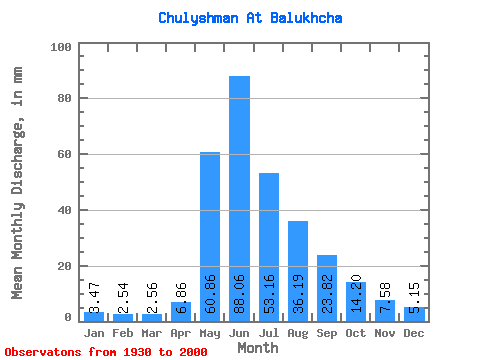
| Statistic | Jan | Feb | Mar | Apr | May | Jun | Jul | Aug | Sep | Oct | Nov | Dec | Annual |
|---|---|---|---|---|---|---|---|---|---|---|---|---|---|
| Mean | 3.47 | 2.56 | 2.56 | 6.86 | 60.85 | 88.06 | 53.16 | 36.18 | 23.82 | 14.19 | 7.58 | 5.15 | 303.93 |
| Standard Deviation | 1.39 | 0.93 | 1.14 | 4.21 | 19.25 | 34.80 | 18.81 | 14.77 | 7.56 | 4.66 | 2.17 | 1.85 | 63.72 |
| Min | 1.43 | 1.02 | 0.71 | 1.92 | 8.36 | 33.57 | 18.71 | 12.79 | 10.65 | 6.86 | 3.59 | 2.66 | 194.46 |
| Max | 9.07 | 5.20 | 5.86 | 26.86 | 126.64 | 213.92 | 100.02 | 95.02 | 42.00 | 33.07 | 13.88 | 11.50 | 471.55 |
| Coefficient of Variation | 0.40 | 0.36 | 0.44 | 0.61 | 0.32 | 0.40 | 0.35 | 0.41 | 0.32 | 0.33 | 0.29 | 0.36 | 0.21 |
 Return to R-Arctic Net Home Page