|
|
|||||||||||||||||
| Point ID: 6675 | Downloads | Plots | Site Data | Code: 10057 |
|
|
|||||||||||||||||
| Download | |
|---|---|
| Site Descriptor Information | Site Time Series Data |
| Link to all available data | |
| View: | Time Series | All |
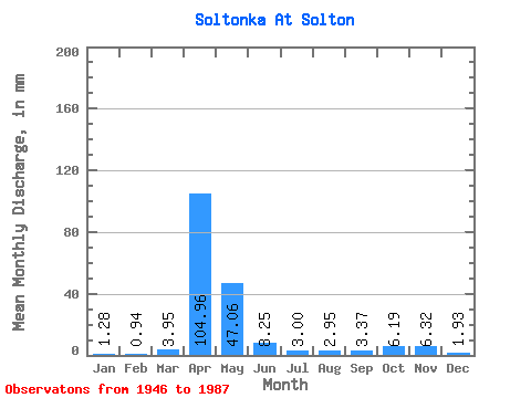
| Units: | m3/s |
| Statistic | Jan | Feb | Mar | Apr | May | Jun | Jul | Aug | Sep | Oct | Nov | Dec | Annual |
|---|---|---|---|---|---|---|---|---|---|---|---|---|---|
| Mean | 1.27 | 0.95 | 3.96 | 104.95 | 47.05 | 8.25 | 3.00 | 2.96 | 3.37 | 6.18 | 6.32 | 1.92 | 192.39 |
| Standard Deviation | 1.12 | 0.82 | 9.91 | 63.05 | 41.04 | 7.53 | 2.13 | 3.16 | 2.67 | 3.68 | 9.59 | 2.03 | 81.94 |
| Min | 0.00 | 0.00 | 0.00 | 5.97 | 8.93 | 1.67 | 0.49 | 0.13 | 0.64 | 0.83 | 0.58 | 0.00 | 41.39 |
| Max | 4.25 | 3.10 | 56.11 | 283.89 | 176.62 | 43.61 | 9.35 | 14.88 | 10.29 | 15.94 | 50.61 | 10.41 | 357.30 |
| Coefficient of Variation | 0.88 | 0.87 | 2.50 | 0.60 | 0.87 | 0.91 | 0.71 | 1.07 | 0.79 | 0.59 | 1.52 | 1.06 | 0.43 |
 Return to R-Arctic Net Home Page