|
|
|||||||||||||||||
| Point ID: 6669 | Downloads | Plots | Site Data | Code: 10044 |
|
|
|||||||||||||||||
| Download | |
|---|---|
| Site Descriptor Information | Site Time Series Data |
| Link to all available data | |
| View: | Time Series | All |
| Units: | m3/s |
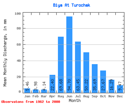
| Statistic | Jan | Feb | Mar | Apr | May | Jun | Jul | Aug | Sep | Oct | Nov | Dec | Annual |
|---|---|---|---|---|---|---|---|---|---|---|---|---|---|
| Mean | 5.46 | 4.02 | 4.14 | 22.40 | 69.67 | 94.70 | 63.45 | 50.21 | 35.69 | 27.66 | 16.29 | 9.47 | 403.96 |
| Standard Deviation | 1.51 | 0.94 | 1.59 | 6.60 | 16.66 | 34.37 | 20.99 | 24.08 | 10.15 | 7.98 | 3.51 | 2.72 | 78.45 |
| Min | 2.79 | 2.14 | 1.94 | 11.88 | 41.60 | 52.76 | 31.75 | 19.79 | 19.88 | 16.09 | 9.80 | 4.89 | 259.09 |
| Max | 8.69 | 6.68 | 8.04 | 36.58 | 128.08 | 198.75 | 131.25 | 116.44 | 53.99 | 51.44 | 24.59 | 15.88 | 586.56 |
| Coefficient of Variation | 0.28 | 0.23 | 0.38 | 0.29 | 0.24 | 0.36 | 0.33 | 0.48 | 0.28 | 0.29 | 0.22 | 0.29 | 0.19 |
 Return to R-Arctic Net Home Page