|
|
|||||||||||||||||
| Point ID: 6666 | Downloads | Plots | Site Data | Other Close Sites | Code: 10031 |
|
|
|||||||||||||||||
| Download | |
|---|---|
| Site Descriptor Information | Site Time Series Data |
| Link to all available data | |
| View: | Time Series | All |
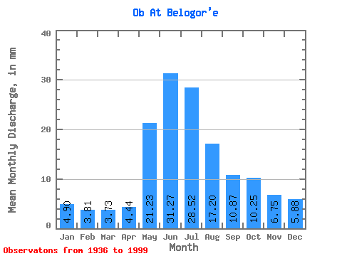
| Units: | m3/s |
| Statistic | Jan | Feb | Mar | Apr | May | Jun | Jul | Aug | Sep | Oct | Nov | Dec | Annual |
|---|---|---|---|---|---|---|---|---|---|---|---|---|---|
| Mean | 3.93 | 3.09 | 3.00 | 3.57 | 17.05 | 25.11 | 22.90 | 13.81 | 8.73 | 8.23 | 5.42 | 4.72 | 118.91 |
| Standard Deviation | 0.66 | 0.49 | 0.49 | 0.97 | 4.26 | 3.34 | 6.48 | 5.45 | 2.15 | 2.13 | 1.30 | 0.88 | 19.02 |
| Min | 2.78 | 2.16 | 2.09 | 2.02 | 1.79 | 15.99 | 9.96 | 6.40 | 5.10 | 4.74 | 3.08 | 2.95 | 84.53 |
| Max | 5.58 | 4.18 | 4.10 | 6.32 | 24.09 | 35.46 | 45.40 | 28.97 | 15.51 | 14.24 | 8.22 | 6.78 | 163.18 |
| Coefficient of Variation | 0.17 | 0.16 | 0.16 | 0.27 | 0.25 | 0.13 | 0.28 | 0.40 | 0.25 | 0.26 | 0.24 | 0.19 | 0.16 |
| Other Close Sites | ||||||
|---|---|---|---|---|---|---|
| PointID | Latitude | Longitude | Drainage Area | Source | Name | |
| 6954 | "Irtish At Khanty-Mansiysk" | 60.97 | -1140871 | SHI | 20.00 | |
 Return to R-Arctic Net Home Page