|
|
|||||||||||||||||
| Point ID: 6658 | Downloads | Plots | Site Data | Code: 10006 |
|
|
|||||||||||||||||
| Download | |
|---|---|
| Site Descriptor Information | Site Time Series Data |
| Link to all available data | |
| View: | Time Series | All |
| Units: | m3/s |
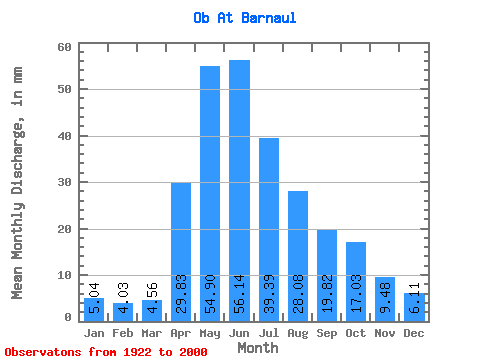
| Statistic | Jan | Feb | Mar | Apr | May | Jun | Jul | Aug | Sep | Oct | Nov | Dec | Annual |
|---|---|---|---|---|---|---|---|---|---|---|---|---|---|
| Mean | 5.04 | 4.06 | 4.56 | 29.83 | 54.90 | 56.14 | 39.38 | 28.08 | 19.82 | 17.03 | 9.48 | 6.11 | 273.95 |
| Standard Deviation | 0.90 | 0.76 | 1.09 | 10.57 | 13.32 | 16.99 | 12.34 | 8.48 | 5.95 | 5.09 | 3.22 | 1.49 | 49.10 |
| Min | 3.15 | 2.86 | 3.03 | 7.12 | 25.99 | 25.00 | 19.33 | 14.97 | 10.21 | 7.94 | 5.14 | 3.77 | 190.82 |
| Max | 7.08 | 6.18 | 9.35 | 60.12 | 105.06 | 108.59 | 90.80 | 61.80 | 38.65 | 35.65 | 20.09 | 10.17 | 429.02 |
| Coefficient of Variation | 0.18 | 0.19 | 0.24 | 0.35 | 0.24 | 0.30 | 0.31 | 0.30 | 0.30 | 0.30 | 0.34 | 0.24 | 0.18 |
 Return to R-Arctic Net Home Page