|
|
|||||||||||||||||
| Point ID: 6657 | Downloads | Plots | Site Data | Other Close Sites | Code: 10002 |
|
|
|||||||||||||||||
| Download | |
|---|---|
| Site Descriptor Information | Site Time Series Data |
| Link to all available data | |
| View: | Time Series | All |
| Units: | m3/s |
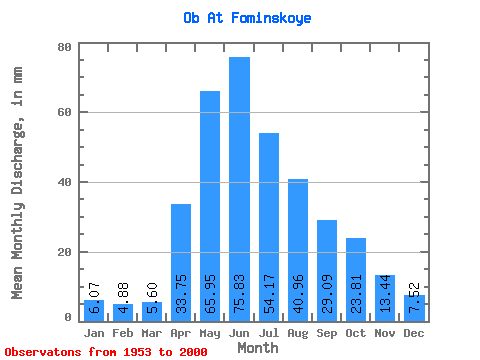
| Statistic | Jan | Feb | Mar | Apr | May | Jun | Jul | Aug | Sep | Oct | Nov | Dec | Annual |
|---|---|---|---|---|---|---|---|---|---|---|---|---|---|
| Mean | 6.07 | 4.92 | 5.60 | 33.75 | 65.94 | 75.83 | 54.16 | 40.95 | 29.09 | 23.81 | 13.44 | 7.51 | 360.03 |
| Standard Deviation | 1.39 | 1.28 | 1.34 | 9.90 | 16.01 | 23.75 | 16.75 | 13.16 | 8.19 | 7.04 | 3.73 | 1.81 | 63.28 |
| Min | 2.00 | 1.35 | 1.66 | 12.04 | 0.63 | 41.70 | 30.00 | 22.28 | 14.78 | 13.17 | 8.18 | 3.71 | 249.40 |
| Max | 10.04 | 7.70 | 8.45 | 60.97 | 118.36 | 144.12 | 113.17 | 82.90 | 50.94 | 44.45 | 23.28 | 12.54 | 532.16 |
| Coefficient of Variation | 0.23 | 0.26 | 0.24 | 0.29 | 0.24 | 0.31 | 0.31 | 0.32 | 0.28 | 0.30 | 0.28 | 0.24 | 0.18 |
| Other Close Sites | ||||||
|---|---|---|---|---|---|---|
| PointID | Latitude | Longitude | Drainage Area | Source | Name | |
| 6670 | "Biya At Biysk" | 52.55 | -336606 | SHI | 21.00 | |
 Return to R-Arctic Net Home Page