|
|
|||||||||||||||||
| Point ID: 6634 | Downloads | Plots | Site Data | Code: 9431 |
|
|
|||||||||||||||||
| Download | |
|---|---|
| Site Descriptor Information | Site Time Series Data |
| Link to all available data | |
| View: | Time Series | All |
| Units: | m3/s |
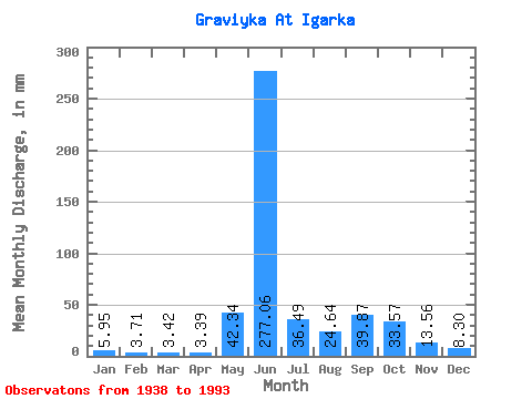
| Statistic | Jan | Feb | Mar | Apr | May | Jun | Jul | Aug | Sep | Oct | Nov | Dec | Annual |
|---|---|---|---|---|---|---|---|---|---|---|---|---|---|
| Mean | 5.94 | 3.75 | 3.42 | 3.38 | 42.33 | 277.06 | 36.49 | 24.63 | 39.87 | 33.56 | 13.56 | 8.30 | 496.65 |
| Standard Deviation | 2.73 | 1.92 | 1.94 | 1.91 | 51.79 | 99.31 | 21.27 | 21.59 | 26.46 | 18.78 | 7.20 | 4.24 | 101.67 |
| Min | 1.91 | 0.64 | 0.77 | 0.53 | 1.33 | 57.46 | 6.38 | 3.07 | 3.45 | 3.81 | 3.13 | 1.74 | 285.64 |
| Max | 14.76 | 8.16 | 8.29 | 8.75 | 247.07 | 536.86 | 92.86 | 111.10 | 116.36 | 77.44 | 31.70 | 18.49 | 700.25 |
| Coefficient of Variation | 0.46 | 0.51 | 0.57 | 0.56 | 1.22 | 0.36 | 0.58 | 0.88 | 0.66 | 0.56 | 0.53 | 0.51 | 0.20 |
 Return to R-Arctic Net Home Page