|
|
|||||||||||||||||
| Point ID: 6628 | Downloads | Plots | Site Data | Code: 9417 |
|
|
|||||||||||||||||
| Download | |
|---|---|
| Site Descriptor Information | Site Time Series Data |
| Link to all available data | |
| View: | Time Series | All |
| Units: | m3/s |
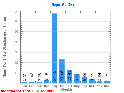
| Statistic | Jan | Feb | Mar | Apr | May | Jun | Jul | Aug | Sep | Oct | Nov | Dec | Annual |
|---|---|---|---|---|---|---|---|---|---|---|---|---|---|
| Mean | 1.39 | 1.03 | 0.98 | 3.15 | 67.71 | 23.06 | 12.40 | 8.52 | 6.06 | 3.55 | 2.04 | 1.75 | 130.50 |
| Standard Deviation | 0.85 | 0.75 | 0.82 | 6.65 | 18.12 | 12.86 | 9.66 | 8.87 | 3.38 | 1.34 | 1.01 | 0.95 | 34.87 |
| Min | 0.43 | 0.30 | 0.26 | 0.24 | 16.00 | 5.13 | 2.71 | 2.32 | 2.19 | 1.48 | 0.84 | 0.63 | 61.90 |
| Max | 4.95 | 4.03 | 4.20 | 35.60 | 103.01 | 61.00 | 40.17 | 48.02 | 14.20 | 6.39 | 5.81 | 5.55 | 217.96 |
| Coefficient of Variation | 0.61 | 0.73 | 0.83 | 2.11 | 0.27 | 0.56 | 0.78 | 1.04 | 0.56 | 0.38 | 0.49 | 0.54 | 0.27 |
 Return to R-Arctic Net Home Page