|
|
|||||||||||||||||
| Point ID: 6621 | Downloads | Plots | Site Data | Code: 9403 |
|
|
|||||||||||||||||
| Download | |
|---|---|
| Site Descriptor Information | Site Time Series Data |
| Link to all available data | |
| View: | Time Series | All |
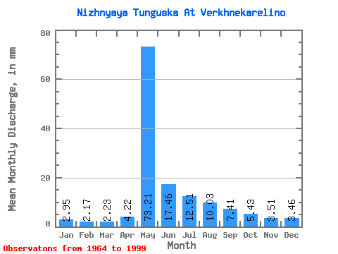
| Units: | m3/s |
| Statistic | Jan | Feb | Mar | Apr | May | Jun | Jul | Aug | Sep | Oct | Nov | Dec | Annual |
|---|---|---|---|---|---|---|---|---|---|---|---|---|---|
| Mean | 2.94 | 2.19 | 2.23 | 4.22 | 73.20 | 17.46 | 12.50 | 10.03 | 7.41 | 5.43 | 3.51 | 3.46 | 143.27 |
| Standard Deviation | 1.38 | 1.00 | 1.02 | 3.98 | 17.26 | 8.62 | 9.20 | 7.24 | 3.14 | 2.23 | 1.46 | 1.70 | 33.97 |
| Min | 1.00 | 0.77 | 0.79 | 1.00 | 42.49 | 5.93 | 3.07 | 2.81 | 2.73 | 1.88 | 1.02 | 1.38 | 80.32 |
| Max | 6.42 | 4.30 | 4.75 | 21.12 | 108.15 | 43.18 | 37.21 | 34.51 | 12.90 | 9.85 | 7.04 | 9.46 | 236.12 |
| Coefficient of Variation | 0.47 | 0.46 | 0.46 | 0.94 | 0.24 | 0.49 | 0.74 | 0.72 | 0.42 | 0.41 | 0.42 | 0.49 | 0.24 |
 Return to R-Arctic Net Home Page