|
|
|||||||||||||||||
| Point ID: 6620 | Downloads | Plots | Site Data | Code: 9401 |
|
|
|||||||||||||||||
| Download | |
|---|---|
| Site Descriptor Information | Site Time Series Data |
| Link to all available data | |
| View: | Time Series | All |
| Units: | m3/s |
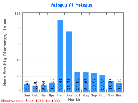
| Statistic | Jan | Feb | Mar | Apr | May | Jun | Jul | Aug | Sep | Oct | Nov | Dec | Annual |
|---|---|---|---|---|---|---|---|---|---|---|---|---|---|
| Mean | 9.46 | 8.05 | 8.64 | 11.23 | 90.40 | 75.71 | 24.89 | 24.68 | 23.97 | 20.94 | 13.29 | 11.19 | 321.50 |
| Standard Deviation | 1.94 | 1.70 | 2.05 | 9.10 | 28.05 | 36.32 | 11.57 | 23.60 | 10.71 | 8.25 | 3.18 | 2.75 | 59.04 |
| Min | 6.00 | 4.06 | 4.57 | 5.34 | 14.56 | 25.76 | 11.39 | 11.04 | 10.13 | 9.09 | 8.19 | 7.11 | 247.49 |
| Max | 15.66 | 13.47 | 15.20 | 59.16 | 159.53 | 203.54 | 64.73 | 152.79 | 49.77 | 40.25 | 19.72 | 22.34 | 506.91 |
| Coefficient of Variation | 0.20 | 0.21 | 0.24 | 0.81 | 0.31 | 0.48 | 0.47 | 0.96 | 0.45 | 0.39 | 0.24 | 0.25 | 0.18 |
 Return to R-Arctic Net Home Page