|
|
|||||||||||||||||
| Point ID: 662 | Downloads | Plots | Site Data | Code: 07BE003 |
|
|
|||||||||||||||||
| Download | |
|---|---|
| Site Descriptor Information | Site Time Series Data |
| Link to all available data | |
| View: | Time Series | All |
| Units: | m3/s |
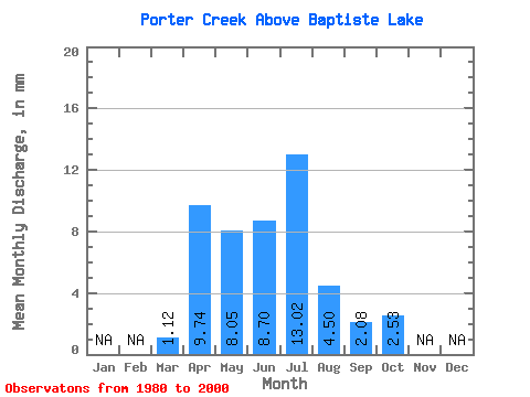
| Statistic | Jan | Feb | Mar | Apr | May | Jun | Jul | Aug | Sep | Oct | Nov | Dec | Annual |
|---|---|---|---|---|---|---|---|---|---|---|---|---|---|
| Mean | 1.11 | 9.74 | 8.04 | 8.68 | 13.03 | 4.48 | 2.10 | 2.52 | |||||
| Standard Deviation | 0.82 | 14.11 | 8.37 | 9.56 | 19.14 | 4.68 | 1.65 | 1.74 | |||||
| Min | 0.00 | 1.04 | 1.17 | 0.95 | 0.70 | 0.66 | 0.68 | 0.89 | |||||
| Max | 3.89 | 61.17 | 34.93 | 38.52 | 75.38 | 17.98 | 7.39 | 7.12 | |||||
| Coefficient of Variation | 0.73 | 1.45 | 1.04 | 1.10 | 1.47 | 1.04 | 0.78 | 0.69 |
 Return to R-Arctic Net Home Page