|
|
|||||||||||||||||
| Point ID: 6619 | Downloads | Plots | Site Data | Code: 9397 |
|
|
|||||||||||||||||
| Download | |
|---|---|
| Site Descriptor Information | Site Time Series Data |
| Link to all available data | |
| View: | Time Series | All |
| Units: | m3/s |
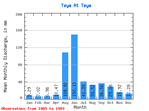
| Statistic | Jan | Feb | Mar | Apr | May | Jun | Jul | Aug | Sep | Oct | Nov | Dec | Annual |
|---|---|---|---|---|---|---|---|---|---|---|---|---|---|
| Mean | 9.29 | 7.08 | 6.96 | 10.47 | 108.80 | 150.13 | 41.32 | 33.51 | 36.56 | 29.07 | 15.92 | 12.28 | 460.75 |
| Standard Deviation | 2.64 | 1.87 | 1.77 | 7.56 | 34.42 | 54.00 | 10.12 | 14.23 | 17.00 | 14.49 | 6.08 | 3.65 | 88.53 |
| Min | 5.59 | 4.38 | 4.49 | 5.43 | 45.37 | 57.27 | 27.98 | 15.74 | 14.96 | 9.57 | 6.79 | 4.42 | 293.80 |
| Max | 16.11 | 11.57 | 11.04 | 45.43 | 204.30 | 269.89 | 64.23 | 69.48 | 74.02 | 72.24 | 27.88 | 19.23 | 605.63 |
| Coefficient of Variation | 0.28 | 0.27 | 0.25 | 0.72 | 0.32 | 0.36 | 0.24 | 0.42 | 0.47 | 0.50 | 0.38 | 0.30 | 0.19 |
 Return to R-Arctic Net Home Page