|
|
|||||||||||||||||
| Point ID: 6618 | Downloads | Plots | Site Data | Code: 9394 |
|
|
|||||||||||||||||
| Download | |
|---|---|
| Site Descriptor Information | Site Time Series Data |
| Link to all available data | |
| View: | Time Series | All |
| Units: | m3/s |
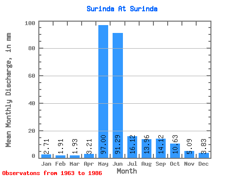
| Statistic | Jan | Feb | Mar | Apr | May | Jun | Jul | Aug | Sep | Oct | Nov | Dec | Annual |
|---|---|---|---|---|---|---|---|---|---|---|---|---|---|
| Mean | 2.71 | 1.93 | 1.93 | 3.21 | 96.98 | 91.29 | 16.12 | 13.96 | 14.12 | 10.63 | 5.09 | 3.83 | 273.39 |
| Standard Deviation | 1.97 | 1.29 | 1.11 | 3.17 | 40.12 | 61.82 | 11.23 | 14.01 | 13.01 | 10.32 | 3.42 | 2.47 | 82.55 |
| Min | 0.43 | 0.17 | 0.01 | 0.01 | 16.99 | 21.40 | 4.91 | 3.60 | 2.39 | 1.71 | 1.42 | 1.11 | 195.85 |
| Max | 8.20 | 4.99 | 3.67 | 13.07 | 155.94 | 245.44 | 44.32 | 61.62 | 53.45 | 37.45 | 14.43 | 11.92 | 442.24 |
| Coefficient of Variation | 0.73 | 0.67 | 0.57 | 0.99 | 0.41 | 0.68 | 0.70 | 1.00 | 0.92 | 0.97 | 0.67 | 0.65 | 0.30 |
 Return to R-Arctic Net Home Page