|
|
|||||||||||||||||
| Point ID: 6609 | Downloads | Plots | Site Data | Code: 9380 |
|
|
|||||||||||||||||
| Download | |
|---|---|
| Site Descriptor Information | Site Time Series Data |
| Link to all available data | |
| View: | Time Series | All |
| Units: | m3/s |
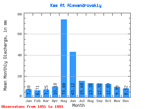
| Statistic | Jan | Feb | Mar | Apr | May | Jun | Jul | Aug | Sep | Oct | Nov | Dec | Annual |
|---|---|---|---|---|---|---|---|---|---|---|---|---|---|
| Mean | 7.68 | 6.77 | 7.25 | 10.18 | 73.87 | 43.12 | 15.68 | 13.35 | 12.92 | 12.88 | 9.99 | 8.52 | 220.92 |
| Standard Deviation | 0.80 | 0.60 | 0.68 | 4.47 | 16.07 | 19.39 | 3.65 | 3.96 | 4.36 | 4.37 | 2.42 | 1.21 | 32.26 |
| Min | 6.42 | 5.40 | 5.85 | 6.28 | 43.81 | 19.44 | 11.50 | 9.11 | 8.45 | 4.87 | 7.06 | 6.87 | 159.97 |
| Max | 9.60 | 8.43 | 9.29 | 24.16 | 105.51 | 97.37 | 32.53 | 24.01 | 26.84 | 27.87 | 18.42 | 11.60 | 307.44 |
| Coefficient of Variation | 0.10 | 0.09 | 0.09 | 0.44 | 0.22 | 0.45 | 0.23 | 0.30 | 0.34 | 0.34 | 0.24 | 0.14 | 0.15 |
 Return to R-Arctic Net Home Page