|
|
|||||||||||||||||
| Point ID: 6601 | Downloads | Plots | Site Data | Code: 9356 |
|
|
|||||||||||||||||
| Download | |
|---|---|
| Site Descriptor Information | Site Time Series Data |
| Link to all available data | |
| View: | Time Series | All |
| Units: | m3/s |
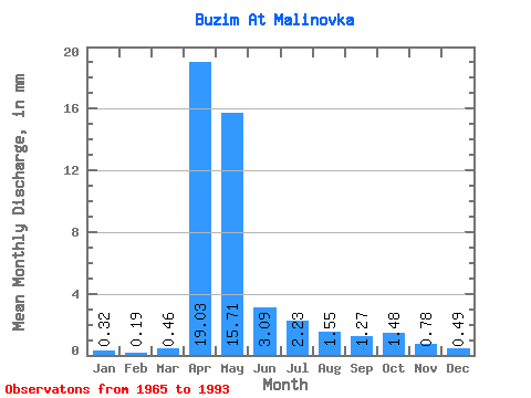
| Statistic | Jan | Feb | Mar | Apr | May | Jun | Jul | Aug | Sep | Oct | Nov | Dec | Annual |
|---|---|---|---|---|---|---|---|---|---|---|---|---|---|
| Mean | 0.32 | 0.20 | 0.46 | 19.03 | 15.71 | 3.09 | 2.23 | 1.55 | 1.27 | 1.48 | 0.78 | 0.49 | 48.52 |
| Standard Deviation | 0.19 | 0.15 | 0.60 | 10.60 | 14.43 | 1.20 | 3.35 | 1.23 | 0.53 | 0.54 | 0.35 | 0.30 | 21.82 |
| Min | 0.00 | 0.00 | 0.00 | 5.85 | 5.08 | 0.70 | 0.46 | 0.60 | 0.42 | 0.85 | 0.35 | 0.11 | 19.79 |
| Max | 0.65 | 0.50 | 2.27 | 44.87 | 76.62 | 5.53 | 17.77 | 6.37 | 2.44 | 2.88 | 1.78 | 1.32 | 108.60 |
| Coefficient of Variation | 0.61 | 0.79 | 1.31 | 0.56 | 0.92 | 0.39 | 1.50 | 0.80 | 0.42 | 0.36 | 0.44 | 0.62 | 0.45 |
 Return to R-Arctic Net Home Page