|
|
|||||||||||||||||
| Point ID: 6597 | Downloads | Plots | Site Data | Code: 9342 |
|
|
|||||||||||||||||
| Download | |
|---|---|
| Site Descriptor Information | Site Time Series Data |
| Link to all available data | |
| View: | Time Series | All |
| Units: | m3/s |
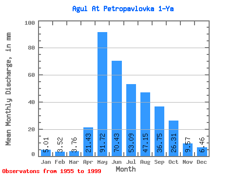
| Statistic | Jan | Feb | Mar | Apr | May | Jun | Jul | Aug | Sep | Oct | Nov | Dec | Annual |
|---|---|---|---|---|---|---|---|---|---|---|---|---|---|
| Mean | 5.01 | 3.56 | 3.76 | 21.43 | 91.71 | 70.43 | 53.08 | 47.14 | 36.75 | 26.30 | 9.57 | 6.46 | 373.31 |
| Standard Deviation | 1.06 | 0.84 | 0.90 | 14.23 | 32.24 | 23.10 | 17.77 | 25.08 | 15.10 | 10.46 | 2.86 | 1.34 | 74.98 |
| Min | 3.17 | 1.42 | 1.60 | 4.73 | 30.51 | 41.47 | 26.78 | 17.00 | 12.85 | 10.20 | 4.17 | 4.05 | 219.37 |
| Max | 6.92 | 5.18 | 5.61 | 59.73 | 184.67 | 132.08 | 98.74 | 155.32 | 83.39 | 54.03 | 16.23 | 9.83 | 529.29 |
| Coefficient of Variation | 0.21 | 0.24 | 0.24 | 0.66 | 0.35 | 0.33 | 0.34 | 0.53 | 0.41 | 0.40 | 0.30 | 0.21 | 0.20 |
 Return to R-Arctic Net Home Page