|
|
|||||||||||||||||
| Point ID: 6585 | Downloads | Plots | Site Data | Code: 9290 |
|
|
|||||||||||||||||
| Download | |
|---|---|
| Site Descriptor Information | Site Time Series Data |
| Link to all available data | |
| View: | Time Series | All |
| Units: | m3/s |
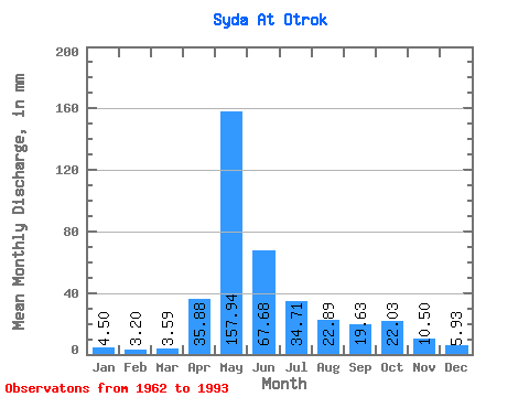
| Statistic | Jan | Feb | Mar | Apr | May | Jun | Jul | Aug | Sep | Oct | Nov | Dec | Annual |
|---|---|---|---|---|---|---|---|---|---|---|---|---|---|
| Mean | 4.50 | 3.23 | 3.59 | 35.88 | 157.91 | 67.68 | 34.71 | 22.89 | 19.63 | 22.02 | 10.50 | 5.93 | 386.03 |
| Standard Deviation | 1.42 | 1.22 | 1.17 | 22.70 | 58.69 | 40.39 | 25.73 | 17.36 | 14.66 | 13.37 | 5.11 | 1.76 | 109.19 |
| Min | 2.59 | 1.78 | 1.72 | 4.57 | 60.80 | 17.27 | 11.07 | 5.81 | 4.31 | 5.88 | 4.27 | 3.24 | 198.32 |
| Max | 8.47 | 6.51 | 6.15 | 89.14 | 294.94 | 199.65 | 107.12 | 71.29 | 70.58 | 60.62 | 21.54 | 10.86 | 596.16 |
| Coefficient of Variation | 0.32 | 0.38 | 0.33 | 0.63 | 0.37 | 0.60 | 0.74 | 0.76 | 0.75 | 0.61 | 0.49 | 0.30 | 0.28 |
 Return to R-Arctic Net Home Page