|
|
|||||||||||||||||
| Point ID: 6582 | Downloads | Plots | Site Data | Code: 9283 |
|
|
|||||||||||||||||
| Download | |
|---|---|
| Site Descriptor Information | Site Time Series Data |
| Link to all available data | |
| View: | Time Series | All |
| Units: | m3/s |
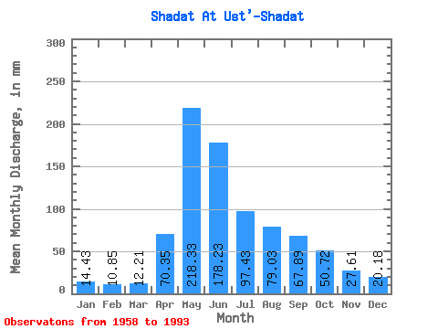
| Statistic | Jan | Feb | Mar | Apr | May | Jun | Jul | Aug | Sep | Oct | Nov | Dec | Annual |
|---|---|---|---|---|---|---|---|---|---|---|---|---|---|
| Mean | 14.43 | 10.95 | 12.21 | 70.34 | 218.30 | 178.23 | 97.42 | 79.02 | 67.89 | 50.72 | 27.61 | 20.17 | 845.40 |
| Standard Deviation | 2.99 | 2.20 | 2.85 | 25.84 | 55.58 | 77.52 | 42.35 | 34.91 | 24.41 | 17.32 | 9.21 | 10.85 | 149.45 |
| Min | 9.15 | 7.26 | 7.84 | 33.79 | 126.41 | 84.09 | 38.42 | 27.58 | 31.32 | 27.90 | 15.74 | 11.16 | 561.35 |
| Max | 23.59 | 16.12 | 19.45 | 149.81 | 339.53 | 408.86 | 243.89 | 159.41 | 144.72 | 111.74 | 63.87 | 76.83 | 1133.11 |
| Coefficient of Variation | 0.21 | 0.20 | 0.23 | 0.37 | 0.26 | 0.43 | 0.43 | 0.44 | 0.36 | 0.34 | 0.33 | 0.54 | 0.18 |
 Return to R-Arctic Net Home Page