|
|
|||||||||||||||||
| Point ID: 6578 | Downloads | Plots | Site Data | Code: 9257 |
|
|
|||||||||||||||||
| Download | |
|---|---|
| Site Descriptor Information | Site Time Series Data |
| Link to all available data | |
| View: | Time Series | All |
| Units: | m3/s |
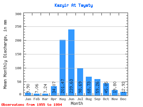
| Statistic | Jan | Feb | Mar | Apr | May | Jun | Jul | Aug | Sep | Oct | Nov | Dec | Annual |
|---|---|---|---|---|---|---|---|---|---|---|---|---|---|
| Mean | 9.89 | 7.12 | 7.24 | 34.07 | 201.44 | 239.63 | 98.68 | 68.72 | 59.26 | 45.04 | 19.80 | 12.93 | 800.96 |
| Standard Deviation | 1.65 | 1.24 | 1.35 | 17.41 | 48.91 | 74.99 | 28.90 | 27.13 | 28.11 | 20.06 | 5.03 | 2.43 | 133.56 |
| Min | 6.77 | 4.57 | 4.95 | 8.91 | 136.15 | 104.33 | 52.88 | 28.58 | 20.04 | 18.41 | 12.26 | 8.60 | 570.36 |
| Max | 13.77 | 9.74 | 11.46 | 77.54 | 355.57 | 481.37 | 168.56 | 138.18 | 162.27 | 123.32 | 29.19 | 17.37 | 1116.16 |
| Coefficient of Variation | 0.17 | 0.17 | 0.19 | 0.51 | 0.24 | 0.31 | 0.29 | 0.40 | 0.47 | 0.45 | 0.25 | 0.19 | 0.17 |
 Return to R-Arctic Net Home Page