|
|
|||||||||||||||||
| Point ID: 6576 | Downloads | Plots | Site Data | Code: 9252 |
|
|
|||||||||||||||||
| Download | |
|---|---|
| Site Descriptor Information | Site Time Series Data |
| Link to all available data | |
| View: | Time Series | All |
| Units: | m3/s |
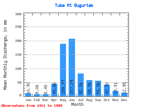
| Statistic | Jan | Feb | Mar | Apr | May | Jun | Jul | Aug | Sep | Oct | Nov | Dec | Annual |
|---|---|---|---|---|---|---|---|---|---|---|---|---|---|
| Mean | 10.90 | 8.13 | 8.44 | 45.86 | 188.95 | 207.29 | 82.55 | 58.95 | 55.96 | 42.30 | 19.91 | 12.98 | 740.74 |
| Standard Deviation | 1.79 | 1.29 | 1.52 | 23.95 | 44.45 | 68.51 | 26.21 | 21.81 | 23.29 | 15.11 | 6.21 | 2.56 | 109.22 |
| Min | 7.05 | 5.33 | 5.22 | 11.41 | 92.64 | 69.53 | 41.10 | 26.95 | 20.70 | 19.20 | 11.33 | 6.91 | 530.53 |
| Max | 14.06 | 10.66 | 13.47 | 149.98 | 336.86 | 458.08 | 140.64 | 120.43 | 141.01 | 109.48 | 44.59 | 18.70 | 1040.17 |
| Coefficient of Variation | 0.17 | 0.16 | 0.18 | 0.52 | 0.23 | 0.33 | 0.32 | 0.37 | 0.42 | 0.36 | 0.31 | 0.20 | 0.15 |
 Return to R-Arctic Net Home Page