|
|
|||||||||||||||||
| Point ID: 6565 | Downloads | Plots | Site Data | Code: 9191 |
|
|
|||||||||||||||||
| Download | |
|---|---|
| Site Descriptor Information | Site Time Series Data |
| Link to all available data | |
| View: | Time Series | All |
| Units: | m3/s |
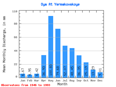
| Statistic | Jan | Feb | Mar | Apr | May | Jun | Jul | Aug | Sep | Oct | Nov | Dec | Annual |
|---|---|---|---|---|---|---|---|---|---|---|---|---|---|
| Mean | 6.67 | 4.99 | 6.41 | 36.93 | 100.82 | 79.68 | 52.06 | 48.45 | 36.35 | 25.18 | 13.29 | 9.01 | 418.21 |
| Standard Deviation | 1.63 | 1.13 | 1.92 | 16.70 | 35.31 | 31.14 | 26.63 | 24.15 | 13.98 | 9.27 | 5.41 | 2.35 | 86.23 |
| Min | 3.84 | 2.96 | 2.81 | 15.21 | 39.85 | 34.80 | 18.45 | 10.32 | 12.25 | 11.81 | 6.32 | 4.59 | 218.65 |
| Max | 10.35 | 8.66 | 12.44 | 99.09 | 196.11 | 181.64 | 148.66 | 111.76 | 71.74 | 46.60 | 30.21 | 14.76 | 626.48 |
| Coefficient of Variation | 0.24 | 0.23 | 0.30 | 0.45 | 0.35 | 0.39 | 0.51 | 0.50 | 0.39 | 0.37 | 0.41 | 0.26 | 0.21 |
 Return to R-Arctic Net Home Page