|
|
|||||||||||||||||
| Point ID: 6561 | Downloads | Plots | Site Data | Code: 9162 |
|
|
|||||||||||||||||
| Download | |
|---|---|
| Site Descriptor Information | Site Time Series Data |
| Link to all available data | |
| View: | Time Series | All |
| Units: | m3/s |
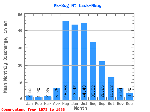
| Statistic | Jan | Feb | Mar | Apr | May | Jun | Jul | Aug | Sep | Oct | Nov | Dec | Annual |
|---|---|---|---|---|---|---|---|---|---|---|---|---|---|
| Mean | 2.62 | 1.92 | 2.39 | 6.76 | 45.58 | 43.42 | 44.48 | 33.51 | 22.25 | 13.22 | 6.64 | 3.90 | 223.44 |
| Standard Deviation | 1.49 | 1.45 | 2.12 | 3.28 | 24.03 | 15.29 | 20.87 | 12.60 | 9.08 | 5.75 | 3.34 | 2.14 | 51.87 |
| Min | 0.43 | 0.38 | 0.35 | 1.71 | 20.13 | 23.18 | 16.97 | 14.01 | 9.88 | 6.19 | 2.29 | 0.58 | 125.39 |
| Max | 5.56 | 5.53 | 6.82 | 12.43 | 117.93 | 77.60 | 79.18 | 63.54 | 42.18 | 29.44 | 14.05 | 8.02 | 306.37 |
| Coefficient of Variation | 0.57 | 0.75 | 0.89 | 0.49 | 0.53 | 0.35 | 0.47 | 0.38 | 0.41 | 0.43 | 0.50 | 0.55 | 0.23 |
 Return to R-Arctic Net Home Page