|
|
|||||||||||||||||
| Point ID: 6558 | Downloads | Plots | Site Data | Code: 9135 |
|
|
|||||||||||||||||
| Download | |
|---|---|
| Site Descriptor Information | Site Time Series Data |
| Link to all available data | |
| View: | Time Series | All |
| Units: | m3/s |
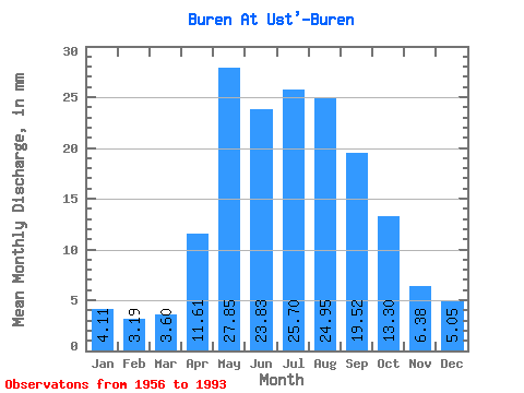
| Statistic | Jan | Feb | Mar | Apr | May | Jun | Jul | Aug | Sep | Oct | Nov | Dec | Annual |
|---|---|---|---|---|---|---|---|---|---|---|---|---|---|
| Mean | 4.11 | 3.22 | 3.60 | 11.61 | 27.84 | 23.83 | 25.69 | 24.94 | 19.52 | 13.30 | 6.38 | 5.05 | 167.06 |
| Standard Deviation | 0.96 | 0.75 | 1.03 | 3.90 | 9.20 | 7.60 | 10.85 | 12.14 | 6.89 | 3.27 | 1.67 | 1.22 | 37.23 |
| Min | 1.89 | 1.62 | 1.68 | 3.94 | 10.93 | 13.48 | 9.63 | 10.17 | 9.84 | 7.17 | 2.90 | 2.33 | 106.99 |
| Max | 6.94 | 4.61 | 5.78 | 19.55 | 47.92 | 38.40 | 47.02 | 56.43 | 37.75 | 21.54 | 10.49 | 7.84 | 252.42 |
| Coefficient of Variation | 0.23 | 0.23 | 0.29 | 0.34 | 0.33 | 0.32 | 0.42 | 0.49 | 0.35 | 0.25 | 0.26 | 0.24 | 0.22 |
 Return to R-Arctic Net Home Page