|
|
|||||||||||||||||
| Point ID: 6553 | Downloads | Plots | Site Data | Code: 9124 |
|
|
|||||||||||||||||
| Download | |
|---|---|
| Site Descriptor Information | Site Time Series Data |
| Link to all available data | |
| View: | Time Series | All |
| Units: | m3/s |
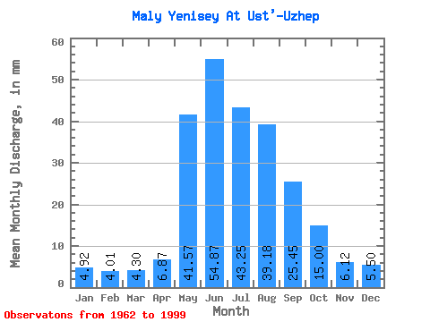
| Statistic | Jan | Feb | Mar | Apr | May | Jun | Jul | Aug | Sep | Oct | Nov | Dec | Annual |
|---|---|---|---|---|---|---|---|---|---|---|---|---|---|
| Mean | 4.92 | 4.04 | 4.30 | 6.87 | 41.56 | 54.87 | 43.25 | 39.18 | 25.45 | 14.99 | 6.12 | 5.50 | 248.21 |
| Standard Deviation | 1.12 | 0.75 | 0.83 | 2.74 | 12.68 | 18.45 | 13.60 | 13.00 | 6.67 | 3.65 | 1.54 | 1.28 | 46.04 |
| Min | 2.54 | 2.22 | 2.23 | 3.35 | 6.01 | 26.35 | 21.71 | 19.75 | 15.81 | 8.99 | 3.36 | 3.23 | 183.07 |
| Max | 7.22 | 5.34 | 6.16 | 17.89 | 63.94 | 107.85 | 70.91 | 72.17 | 45.16 | 23.99 | 9.62 | 8.42 | 383.82 |
| Coefficient of Variation | 0.23 | 0.19 | 0.19 | 0.40 | 0.30 | 0.34 | 0.31 | 0.33 | 0.26 | 0.24 | 0.25 | 0.23 | 0.18 |
 Return to R-Arctic Net Home Page