|
|
|||||||||||||||||
| Point ID: 6531 | Downloads | Plots | Site Data | Code: 8377 |
|
|
|||||||||||||||||
| Download | |
|---|---|
| Site Descriptor Information | Site Time Series Data |
| Link to all available data | |
| View: | Time Series | All |
| Units: | m3/s |
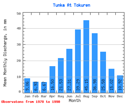
| Statistic | Jan | Feb | Mar | Apr | May | Jun | Jul | Aug | Sep | Oct | Nov | Dec | Annual |
|---|---|---|---|---|---|---|---|---|---|---|---|---|---|
| Mean | 9.05 | 6.99 | 6.67 | 16.50 | 21.52 | 27.31 | 39.28 | 45.14 | 36.98 | 25.58 | 15.02 | 10.92 | 260.55 |
| Standard Deviation | 2.35 | 1.58 | 2.29 | 4.80 | 2.54 | 7.22 | 9.12 | 11.31 | 8.22 | 3.87 | 2.92 | 3.16 | 35.87 |
| Min | 5.42 | 4.42 | 3.70 | 7.51 | 16.97 | 16.59 | 24.34 | 31.44 | 27.42 | 20.21 | 10.23 | 6.27 | 220.29 |
| Max | 14.00 | 9.60 | 10.93 | 23.20 | 24.70 | 39.95 | 53.49 | 66.04 | 54.33 | 34.01 | 20.74 | 17.57 | 310.70 |
| Coefficient of Variation | 0.26 | 0.23 | 0.34 | 0.29 | 0.12 | 0.26 | 0.23 | 0.25 | 0.22 | 0.15 | 0.20 | 0.29 | 0.14 |
 Return to R-Arctic Net Home Page