|
|
|||||||||||||||||
| Point ID: 653 | Downloads | Plots | Site Data | Code: 07BB014 |
|
|
|||||||||||||||||
| Download | |
|---|---|
| Site Descriptor Information | Site Time Series Data |
| Link to all available data | |
| View: | Time Series | All |
| Units: | m3/s |
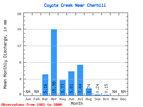
| Statistic | Jan | Feb | Mar | Apr | May | Jun | Jul | Aug | Sep | Oct | Nov | Dec | Annual |
|---|---|---|---|---|---|---|---|---|---|---|---|---|---|
| Mean | 4.84 | 14.93 | 3.53 | 5.44 | 6.95 | 1.62 | 0.21 | 0.13 | |||||
| Standard Deviation | 6.58 | 22.43 | 6.04 | 11.81 | 11.09 | 4.28 | 0.72 | 0.27 | |||||
| Min | 0.00 | 0.00 | 0.00 | 0.00 | 0.00 | 0.00 | 0.00 | 0.00 | |||||
| Max | 27.11 | 91.95 | 25.39 | 44.27 | 35.03 | 15.15 | 3.23 | 0.93 | |||||
| Coefficient of Variation | 1.36 | 1.50 | 1.71 | 2.17 | 1.60 | 2.64 | 3.34 | 2.05 |
 Return to R-Arctic Net Home Page