|
|
|||||||||||||||||
| Point ID: 6524 | Downloads | Plots | Site Data | Code: 8364 |
|
|
|||||||||||||||||
| Download | |
|---|---|
| Site Descriptor Information | Site Time Series Data |
| Link to all available data | |
| View: | Time Series | All |
| Units: | m3/s |
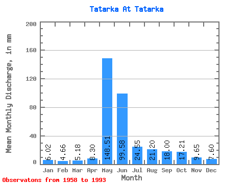
| Statistic | Jan | Feb | Mar | Apr | May | Jun | Jul | Aug | Sep | Oct | Nov | Dec | Annual |
|---|---|---|---|---|---|---|---|---|---|---|---|---|---|
| Mean | 6.02 | 4.70 | 5.18 | 8.30 | 148.49 | 99.58 | 24.54 | 21.20 | 18.00 | 17.21 | 9.65 | 7.60 | 368.69 |
| Standard Deviation | 1.33 | 1.16 | 1.15 | 3.51 | 34.55 | 48.29 | 9.28 | 17.69 | 7.94 | 8.13 | 3.15 | 1.94 | 72.26 |
| Min | 3.15 | 1.97 | 2.59 | 4.96 | 68.80 | 33.50 | 13.70 | 7.95 | 7.18 | 6.77 | 5.90 | 3.79 | 239.97 |
| Max | 9.54 | 6.44 | 8.15 | 19.03 | 223.64 | 237.14 | 59.26 | 109.68 | 37.50 | 38.18 | 17.10 | 11.85 | 540.33 |
| Coefficient of Variation | 0.22 | 0.25 | 0.22 | 0.42 | 0.23 | 0.48 | 0.38 | 0.83 | 0.44 | 0.47 | 0.33 | 0.26 | 0.20 |
 Return to R-Arctic Net Home Page