|
|
|||||||||||||||||
| Point ID: 6523 | Downloads | Plots | Site Data | Code: 8363 |
|
|
|||||||||||||||||
| Download | |
|---|---|
| Site Descriptor Information | Site Time Series Data |
| Link to all available data | |
| View: | Time Series | All |
| Units: | m3/s |
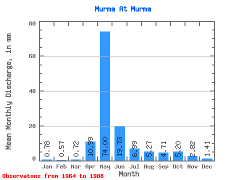
| Statistic | Jan | Feb | Mar | Apr | May | Jun | Jul | Aug | Sep | Oct | Nov | Dec | Annual |
|---|---|---|---|---|---|---|---|---|---|---|---|---|---|
| Mean | 0.78 | 0.57 | 0.72 | 10.99 | 73.99 | 19.73 | 6.99 | 5.27 | 4.71 | 5.20 | 2.82 | 1.41 | 132.16 |
| Standard Deviation | 0.41 | 0.34 | 0.35 | 9.84 | 24.80 | 10.53 | 4.78 | 3.32 | 2.64 | 2.63 | 1.71 | 0.86 | 35.72 |
| Min | 0.07 | 0.03 | 0.03 | 1.06 | 36.63 | 5.89 | 2.85 | 1.89 | 1.91 | 1.97 | 0.97 | 0.30 | 74.50 |
| Max | 1.58 | 1.21 | 1.24 | 32.76 | 136.26 | 39.61 | 21.64 | 17.10 | 11.51 | 11.03 | 7.09 | 4.54 | 204.72 |
| Coefficient of Variation | 0.53 | 0.59 | 0.48 | 0.90 | 0.34 | 0.53 | 0.68 | 0.63 | 0.56 | 0.51 | 0.61 | 0.61 | 0.27 |
 Return to R-Arctic Net Home Page