|
|
|||||||||||||||||
| Point ID: 6522 | Downloads | Plots | Site Data | Code: 8361 |
|
|
|||||||||||||||||
| Download | |
|---|---|
| Site Descriptor Information | Site Time Series Data |
| Link to all available data | |
| View: | Time Series | All |
| Units: | m3/s |
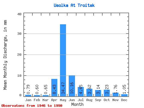
| Statistic | Jan | Feb | Mar | Apr | May | Jun | Jul | Aug | Sep | Oct | Nov | Dec | Annual |
|---|---|---|---|---|---|---|---|---|---|---|---|---|---|
| Mean | 0.79 | 0.60 | 0.66 | 8.43 | 34.46 | 10.16 | 4.45 | 3.62 | 3.14 | 3.23 | 1.76 | 1.05 | 72.05 |
| Standard Deviation | 0.30 | 0.25 | 0.27 | 6.04 | 13.83 | 3.55 | 2.52 | 2.54 | 1.42 | 1.32 | 0.66 | 0.39 | 19.13 |
| Min | 0.33 | 0.27 | 0.31 | 1.25 | 12.28 | 3.43 | 1.97 | 1.27 | 0.97 | 1.26 | 0.60 | 0.36 | 30.00 |
| Max | 1.65 | 1.33 | 1.46 | 24.55 | 83.85 | 17.57 | 12.37 | 13.38 | 6.37 | 6.67 | 3.69 | 2.19 | 118.90 |
| Coefficient of Variation | 0.38 | 0.42 | 0.42 | 0.72 | 0.40 | 0.35 | 0.57 | 0.70 | 0.45 | 0.41 | 0.38 | 0.37 | 0.27 |
 Return to R-Arctic Net Home Page