|
|
|||||||||||||||||
| Point ID: 6520 | Downloads | Plots | Site Data | Code: 8355 |
|
|
|||||||||||||||||
| Download | |
|---|---|
| Site Descriptor Information | Site Time Series Data |
| Link to all available data | |
| View: | Time Series | All |
| Units: | m3/s |
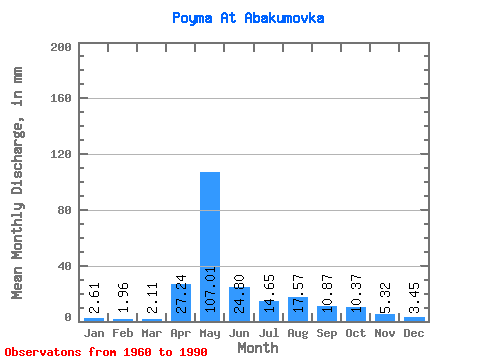
| Statistic | Jan | Feb | Mar | Apr | May | Jun | Jul | Aug | Sep | Oct | Nov | Dec | Annual |
|---|---|---|---|---|---|---|---|---|---|---|---|---|---|
| Mean | 2.61 | 1.98 | 2.11 | 27.24 | 106.99 | 24.80 | 14.64 | 17.57 | 10.87 | 10.37 | 5.32 | 3.45 | 226.28 |
| Standard Deviation | 1.26 | 1.16 | 1.33 | 24.88 | 46.79 | 17.36 | 8.12 | 19.77 | 6.38 | 7.30 | 3.19 | 1.47 | 69.70 |
| Min | 1.02 | 0.12 | 0.40 | 2.79 | 24.07 | 8.07 | 3.56 | 3.59 | 3.53 | 4.01 | 2.21 | 1.50 | 78.43 |
| Max | 5.48 | 4.94 | 6.41 | 93.78 | 235.31 | 83.67 | 35.03 | 79.94 | 25.76 | 39.27 | 17.96 | 7.03 | 378.58 |
| Coefficient of Variation | 0.48 | 0.59 | 0.63 | 0.91 | 0.44 | 0.70 | 0.56 | 1.13 | 0.59 | 0.70 | 0.60 | 0.43 | 0.31 |
 Return to R-Arctic Net Home Page