|
|
|||||||||||||||||
| Point ID: 6519 | Downloads | Plots | Site Data | Code: 8347 |
|
|
|||||||||||||||||
| Download | |
|---|---|
| Site Descriptor Information | Site Time Series Data |
| Link to all available data | |
| View: | Time Series | All |
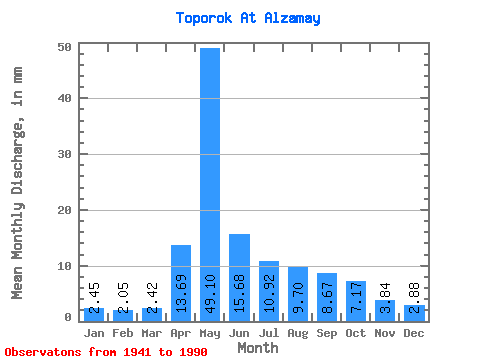
| Units: | m3/s |
| Statistic | Jan | Feb | Mar | Apr | May | Jun | Jul | Aug | Sep | Oct | Nov | Dec | Annual |
|---|---|---|---|---|---|---|---|---|---|---|---|---|---|
| Mean | 2.45 | 2.07 | 2.42 | 13.69 | 49.09 | 15.68 | 10.92 | 9.70 | 8.67 | 7.17 | 3.84 | 2.88 | 127.76 |
| Standard Deviation | 0.51 | 0.47 | 0.54 | 10.59 | 86.54 | 7.61 | 6.58 | 7.39 | 6.33 | 3.54 | 1.45 | 0.70 | 97.76 |
| Min | 0.98 | 0.93 | 1.17 | 3.57 | 9.04 | 5.25 | 4.25 | 3.75 | 3.75 | 3.55 | 2.21 | 1.53 | 55.83 |
| Max | 3.75 | 3.04 | 3.55 | 49.23 | 623.07 | 43.50 | 37.14 | 40.10 | 33.08 | 19.65 | 10.13 | 4.55 | 723.22 |
| Coefficient of Variation | 0.21 | 0.23 | 0.22 | 0.77 | 1.76 | 0.48 | 0.60 | 0.76 | 0.73 | 0.49 | 0.38 | 0.24 | 0.77 |
 Return to R-Arctic Net Home Page