|
|
|||||||||||||||||
| Point ID: 6516 | Downloads | Plots | Site Data | Code: 8340 |
|
|
|||||||||||||||||
| Download | |
|---|---|
| Site Descriptor Information | Site Time Series Data |
| Link to all available data | |
| View: | Time Series | All |
| Units: | m3/s |
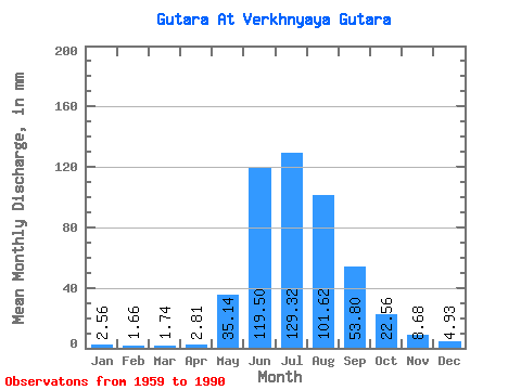
| Statistic | Jan | Feb | Mar | Apr | May | Jun | Jul | Aug | Sep | Oct | Nov | Dec | Annual |
|---|---|---|---|---|---|---|---|---|---|---|---|---|---|
| Mean | 2.56 | 1.68 | 1.74 | 2.81 | 35.14 | 119.50 | 129.30 | 101.60 | 53.80 | 22.56 | 8.68 | 4.93 | 477.20 |
| Standard Deviation | 1.29 | 1.20 | 1.15 | 1.44 | 16.98 | 31.21 | 37.48 | 31.28 | 14.45 | 6.48 | 2.45 | 1.43 | 84.13 |
| Min | 0.75 | 0.34 | 0.38 | 0.56 | 9.44 | 64.55 | 64.64 | 49.59 | 26.28 | 12.62 | 3.11 | 2.33 | 342.71 |
| Max | 7.08 | 6.86 | 6.84 | 5.73 | 71.14 | 199.61 | 214.10 | 158.01 | 87.06 | 44.46 | 15.89 | 9.03 | 622.80 |
| Coefficient of Variation | 0.50 | 0.71 | 0.66 | 0.51 | 0.48 | 0.26 | 0.29 | 0.31 | 0.27 | 0.29 | 0.28 | 0.29 | 0.18 |
 Return to R-Arctic Net Home Page