|
|
|||||||||||||||||
| Point ID: 6514 | Downloads | Plots | Site Data | Code: 8335 |
|
|
|||||||||||||||||
| Download | |
|---|---|
| Site Descriptor Information | Site Time Series Data |
| Link to all available data | |
| View: | Time Series | All |
| Units: | m3/s |
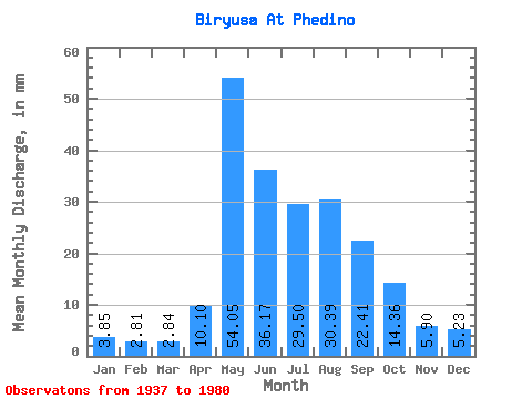
| Statistic | Jan | Feb | Mar | Apr | May | Jun | Jul | Aug | Sep | Oct | Nov | Dec | Annual |
|---|---|---|---|---|---|---|---|---|---|---|---|---|---|
| Mean | 3.85 | 2.84 | 2.84 | 10.10 | 54.04 | 36.17 | 29.49 | 30.38 | 22.41 | 14.35 | 5.90 | 5.23 | 216.41 |
| Standard Deviation | 0.73 | 0.55 | 0.55 | 7.80 | 17.30 | 12.75 | 9.51 | 12.82 | 8.72 | 4.33 | 1.91 | 1.48 | 43.03 |
| Min | 2.38 | 1.84 | 1.72 | 2.83 | 27.46 | 16.82 | 13.86 | 8.87 | 10.62 | 9.03 | 3.42 | 3.16 | 126.75 |
| Max | 5.51 | 4.09 | 4.33 | 35.42 | 108.69 | 75.22 | 55.13 | 80.86 | 63.02 | 29.14 | 11.54 | 12.18 | 309.44 |
| Coefficient of Variation | 0.19 | 0.19 | 0.19 | 0.77 | 0.32 | 0.35 | 0.32 | 0.42 | 0.39 | 0.30 | 0.32 | 0.28 | 0.20 |
 Return to R-Arctic Net Home Page