|
|
|||||||||||||||||
| Point ID: 6513 | Downloads | Plots | Site Data | Code: 8334 |
|
|
|||||||||||||||||
| Download | |
|---|---|
| Site Descriptor Information | Site Time Series Data |
| Link to all available data | |
| View: | Time Series | All |
| Units: | m3/s |
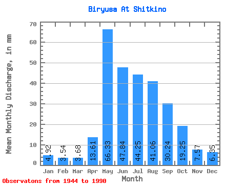
| Statistic | Jan | Feb | Mar | Apr | May | Jun | Jul | Aug | Sep | Oct | Nov | Dec | Annual |
|---|---|---|---|---|---|---|---|---|---|---|---|---|---|
| Mean | 4.92 | 3.57 | 3.68 | 13.61 | 66.33 | 47.84 | 44.24 | 41.05 | 30.24 | 19.25 | 7.57 | 6.34 | 286.50 |
| Standard Deviation | 1.04 | 0.67 | 0.65 | 8.57 | 21.70 | 18.29 | 16.54 | 14.19 | 12.89 | 6.10 | 2.26 | 1.44 | 58.65 |
| Min | 2.85 | 2.25 | 1.94 | 3.04 | 26.44 | 20.95 | 17.01 | 13.31 | 13.53 | 11.37 | 4.61 | 3.59 | 161.99 |
| Max | 7.88 | 5.08 | 5.07 | 34.40 | 120.43 | 103.52 | 89.27 | 78.57 | 94.55 | 37.64 | 12.71 | 10.61 | 399.88 |
| Coefficient of Variation | 0.21 | 0.19 | 0.18 | 0.63 | 0.33 | 0.38 | 0.37 | 0.35 | 0.43 | 0.32 | 0.30 | 0.23 | 0.20 |
 Return to R-Arctic Net Home Page