|
|
|||||||||||||||||
| Point ID: 6498 | Downloads | Plots | Site Data | Code: 8291 |
|
|
|||||||||||||||||
| Download | |
|---|---|
| Site Descriptor Information | Site Time Series Data |
| Link to all available data | |
| View: | Time Series | All |
| Units: | m3/s |
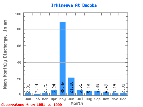
| Statistic | Jan | Feb | Mar | Apr | May | Jun | Jul | Aug | Sep | Oct | Nov | Dec | Annual |
|---|---|---|---|---|---|---|---|---|---|---|---|---|---|
| Mean | 2.81 | 2.46 | 2.71 | 6.24 | 88.45 | 21.86 | 6.61 | 5.16 | 5.39 | 4.49 | 3.19 | 2.93 | 151.63 |
| Standard Deviation | 0.72 | 0.65 | 0.70 | 11.04 | 28.95 | 12.85 | 2.42 | 1.57 | 1.93 | 1.35 | 1.13 | 0.80 | 36.80 |
| Min | 1.60 | 1.49 | 1.77 | 2.07 | 24.06 | 6.78 | 4.07 | 3.32 | 2.81 | 2.78 | 1.65 | 1.55 | 68.90 |
| Max | 5.80 | 5.21 | 5.59 | 73.56 | 187.61 | 63.13 | 13.55 | 12.81 | 13.09 | 10.71 | 8.98 | 6.19 | 268.19 |
| Coefficient of Variation | 0.26 | 0.26 | 0.26 | 1.77 | 0.33 | 0.59 | 0.37 | 0.30 | 0.36 | 0.30 | 0.35 | 0.27 | 0.24 |
 Return to R-Arctic Net Home Page