|
|
|||||||||||||||||
| Point ID: 6493 | Downloads | Plots | Site Data | Code: 8281 |
|
|
|||||||||||||||||
| Download | |
|---|---|
| Site Descriptor Information | Site Time Series Data |
| Link to all available data | |
| View: | Time Series | All |
| Units: | m3/s |
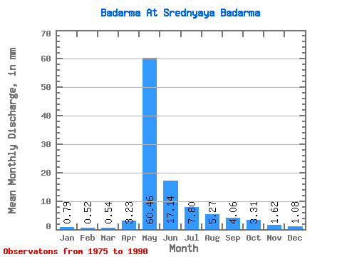
| Statistic | Jan | Feb | Mar | Apr | May | Jun | Jul | Aug | Sep | Oct | Nov | Dec | Annual |
|---|---|---|---|---|---|---|---|---|---|---|---|---|---|
| Mean | 0.79 | 0.53 | 0.54 | 3.23 | 60.45 | 17.14 | 7.80 | 5.27 | 4.06 | 3.31 | 1.62 | 1.08 | 104.83 |
| Standard Deviation | 0.26 | 0.23 | 0.24 | 5.10 | 28.91 | 10.77 | 4.31 | 3.02 | 1.19 | 0.92 | 0.59 | 0.37 | 36.76 |
| Min | 0.39 | 0.15 | 0.17 | 0.36 | 0.65 | 7.12 | 2.65 | 2.38 | 2.48 | 1.88 | 0.78 | 0.67 | 49.01 |
| Max | 1.35 | 1.03 | 1.00 | 18.11 | 109.41 | 42.33 | 18.84 | 13.59 | 6.62 | 5.30 | 2.58 | 1.94 | 184.11 |
| Coefficient of Variation | 0.33 | 0.43 | 0.44 | 1.58 | 0.48 | 0.63 | 0.55 | 0.57 | 0.29 | 0.28 | 0.36 | 0.34 | 0.35 |
 Return to R-Arctic Net Home Page