|
|
|||||||||||||||||
| Point ID: 649 | Downloads | Plots | Site Data | Code: 07BB006 |
|
|
|||||||||||||||||
| Download | |
|---|---|
| Site Descriptor Information | Site Time Series Data |
| Link to all available data | |
| View: | Time Series | All |
| Units: | m3/s |
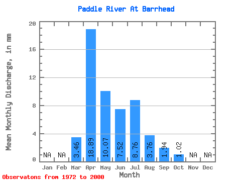
| Statistic | Jan | Feb | Mar | Apr | May | Jun | Jul | Aug | Sep | Oct | Nov | Dec | Annual |
|---|---|---|---|---|---|---|---|---|---|---|---|---|---|
| Mean | 3.24 | 17.70 | 9.43 | 7.05 | 8.20 | 3.52 | 1.82 | 0.95 | |||||
| Standard Deviation | 3.88 | 21.45 | 11.85 | 7.05 | 6.91 | 7.51 | 2.41 | 1.06 | |||||
| Min | 0.04 | 0.21 | 0.21 | 0.81 | 0.17 | 0.03 | 0.01 | 0.03 | |||||
| Max | 14.52 | 106.40 | 55.59 | 24.50 | 28.36 | 41.18 | 10.71 | 3.70 | |||||
| Coefficient of Variation | 1.20 | 1.21 | 1.26 | 1.00 | 0.84 | 2.13 | 1.33 | 1.11 |
 Return to R-Arctic Net Home Page