|
|
|||||||||||||||||
| Point ID: 6486 | Downloads | Plots | Site Data | Code: 8241 |
|
|
|||||||||||||||||
| Download | |
|---|---|
| Site Descriptor Information | Site Time Series Data |
| Link to all available data | |
| View: | Time Series | All |
| Units: | m3/s |
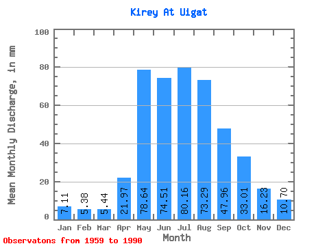
| Statistic | Jan | Feb | Mar | Apr | May | Jun | Jul | Aug | Sep | Oct | Nov | Dec | Annual |
|---|---|---|---|---|---|---|---|---|---|---|---|---|---|
| Mean | 7.11 | 5.43 | 5.44 | 21.98 | 78.62 | 74.51 | 80.15 | 73.28 | 47.96 | 33.00 | 16.23 | 10.70 | 453.85 |
| Standard Deviation | 1.51 | 1.21 | 0.96 | 9.86 | 28.26 | 21.87 | 30.33 | 27.32 | 17.60 | 10.59 | 4.54 | 2.78 | 68.58 |
| Min | 4.71 | 2.81 | 3.30 | 5.70 | 28.96 | 36.99 | 37.85 | 36.40 | 27.06 | 18.52 | 9.93 | 6.78 | 335.84 |
| Max | 11.62 | 8.05 | 7.36 | 43.76 | 128.00 | 140.58 | 176.11 | 149.79 | 99.29 | 66.91 | 26.18 | 16.07 | 626.19 |
| Coefficient of Variation | 0.21 | 0.22 | 0.18 | 0.45 | 0.36 | 0.29 | 0.38 | 0.37 | 0.37 | 0.32 | 0.28 | 0.26 | 0.15 |
 Return to R-Arctic Net Home Page