|
|
|||||||||||||||||
| Point ID: 6485 | Downloads | Plots | Site Data | Code: 8240 |
|
|
|||||||||||||||||
| Download | |
|---|---|
| Site Descriptor Information | Site Time Series Data |
| Link to all available data | |
| View: | Time Series | All |
| Units: | m3/s |
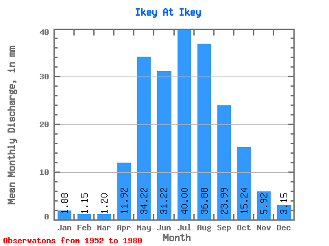
| Statistic | Jan | Feb | Mar | Apr | May | Jun | Jul | Aug | Sep | Oct | Nov | Dec | Annual |
|---|---|---|---|---|---|---|---|---|---|---|---|---|---|
| Mean | 1.89 | 1.16 | 1.20 | 11.92 | 34.22 | 31.22 | 39.99 | 36.87 | 23.99 | 15.24 | 5.92 | 3.15 | 209.49 |
| Standard Deviation | 0.54 | 0.54 | 0.56 | 8.43 | 14.78 | 10.34 | 20.58 | 20.00 | 7.45 | 3.50 | 1.39 | 0.82 | 48.62 |
| Min | 0.85 | 0.07 | 0.39 | 0.99 | 14.28 | 14.04 | 11.72 | 13.61 | 11.56 | 8.96 | 3.00 | 1.54 | 119.08 |
| Max | 2.84 | 2.12 | 2.46 | 41.36 | 64.50 | 53.24 | 80.34 | 91.94 | 47.84 | 22.09 | 8.20 | 4.89 | 308.49 |
| Coefficient of Variation | 0.29 | 0.47 | 0.47 | 0.71 | 0.43 | 0.33 | 0.52 | 0.54 | 0.31 | 0.23 | 0.23 | 0.26 | 0.23 |
 Return to R-Arctic Net Home Page