|
|
|||||||||||||||||
| Point ID: 6484 | Downloads | Plots | Site Data | Code: 8233 |
|
|
|||||||||||||||||
| Download | |
|---|---|
| Site Descriptor Information | Site Time Series Data |
| Link to all available data | |
| View: | Time Series | All |
| Units: | m3/s |
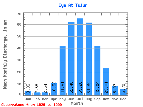
| Statistic | Jan | Feb | Mar | Apr | May | Jun | Jul | Aug | Sep | Oct | Nov | Dec | Annual |
|---|---|---|---|---|---|---|---|---|---|---|---|---|---|
| Mean | 3.94 | 2.70 | 2.64 | 10.53 | 41.50 | 62.46 | 65.19 | 61.63 | 42.05 | 23.01 | 8.07 | 5.70 | 326.86 |
| Standard Deviation | 0.98 | 0.73 | 0.80 | 5.71 | 12.98 | 19.80 | 25.18 | 22.05 | 14.87 | 5.94 | 2.32 | 1.39 | 62.09 |
| Min | 1.76 | 1.05 | 0.93 | 2.16 | 20.50 | 31.10 | 29.00 | 29.18 | 22.88 | 13.63 | 4.04 | 2.27 | 203.98 |
| Max | 6.28 | 5.05 | 5.47 | 27.71 | 71.84 | 124.06 | 135.01 | 139.81 | 110.47 | 41.74 | 16.62 | 8.79 | 501.99 |
| Coefficient of Variation | 0.25 | 0.27 | 0.30 | 0.54 | 0.31 | 0.32 | 0.39 | 0.36 | 0.35 | 0.26 | 0.29 | 0.24 | 0.19 |
 Return to R-Arctic Net Home Page