|
|
|||||||||||||||||
| Point ID: 6483 | Downloads | Plots | Site Data | Code: 8230 |
|
|
|||||||||||||||||
| Download | |
|---|---|
| Site Descriptor Information | Site Time Series Data |
| Link to all available data | |
| View: | Time Series | All |
| Units: | m3/s |
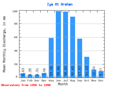
| Statistic | Jan | Feb | Mar | Apr | May | Jun | Jul | Aug | Sep | Oct | Nov | Dec | Annual |
|---|---|---|---|---|---|---|---|---|---|---|---|---|---|
| Mean | 6.63 | 4.38 | 4.30 | 7.06 | 59.05 | 98.86 | 98.19 | 90.64 | 57.97 | 31.03 | 12.00 | 9.37 | 478.58 |
| Standard Deviation | 1.53 | 0.97 | 0.85 | 2.76 | 21.72 | 37.33 | 42.82 | 34.95 | 20.15 | 10.81 | 3.29 | 2.38 | 130.01 |
| Min | 3.83 | 1.92 | 2.78 | 2.62 | 13.96 | 30.56 | 29.12 | 24.28 | 13.06 | 10.63 | 5.29 | 4.76 | 207.07 |
| Max | 10.99 | 6.41 | 5.83 | 11.95 | 102.64 | 201.71 | 233.93 | 191.21 | 94.30 | 54.19 | 19.36 | 14.80 | 697.21 |
| Coefficient of Variation | 0.23 | 0.22 | 0.20 | 0.39 | 0.37 | 0.38 | 0.44 | 0.39 | 0.35 | 0.35 | 0.27 | 0.25 | 0.27 |
 Return to R-Arctic Net Home Page