|
|
|||||||||||||||||
| Point ID: 6482 | Downloads | Plots | Site Data | Code: 8219 |
|
|
|||||||||||||||||
| Download | |
|---|---|
| Site Descriptor Information | Site Time Series Data |
| Link to all available data | |
| View: | Time Series | All |
| Units: | m3/s |
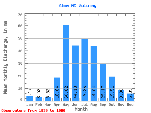
| Statistic | Jan | Feb | Mar | Apr | May | Jun | Jul | Aug | Sep | Oct | Nov | Dec | Annual |
|---|---|---|---|---|---|---|---|---|---|---|---|---|---|
| Mean | 4.17 | 3.06 | 3.32 | 18.64 | 60.61 | 44.18 | 49.35 | 44.04 | 29.17 | 19.50 | 9.00 | 5.89 | 295.71 |
| Standard Deviation | 1.21 | 0.85 | 0.93 | 13.59 | 30.00 | 15.93 | 24.27 | 24.09 | 14.89 | 8.15 | 2.96 | 1.53 | 74.52 |
| Min | 1.75 | 0.97 | 1.46 | 4.29 | 15.54 | 13.72 | 18.48 | 11.55 | 9.60 | 5.81 | 3.17 | 2.50 | 117.70 |
| Max | 6.69 | 4.89 | 5.47 | 75.32 | 133.38 | 86.50 | 128.12 | 119.72 | 84.98 | 46.00 | 15.45 | 8.71 | 452.81 |
| Coefficient of Variation | 0.29 | 0.28 | 0.28 | 0.73 | 0.49 | 0.36 | 0.49 | 0.55 | 0.51 | 0.42 | 0.33 | 0.26 | 0.25 |
 Return to R-Arctic Net Home Page