|
|
|||||||||||||||||
| Point ID: 6472 | Downloads | Plots | Site Data | Code: 8177 |
|
|
|||||||||||||||||
| Download | |
|---|---|
| Site Descriptor Information | Site Time Series Data |
| Link to all available data | |
| View: | Time Series | All |
| Units: | m3/s |
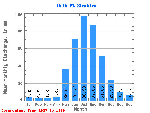
| Statistic | Jan | Feb | Mar | Apr | May | Jun | Jul | Aug | Sep | Oct | Nov | Dec | Annual |
|---|---|---|---|---|---|---|---|---|---|---|---|---|---|
| Mean | 4.32 | 3.02 | 3.03 | 4.87 | 36.03 | 70.77 | 96.91 | 87.05 | 51.65 | 23.30 | 9.77 | 6.17 | 394.19 |
| Standard Deviation | 1.09 | 0.72 | 0.74 | 1.56 | 12.03 | 16.52 | 27.21 | 26.86 | 12.28 | 4.12 | 2.02 | 1.23 | 49.42 |
| Min | 2.22 | 1.58 | 1.64 | 2.98 | 17.49 | 46.38 | 57.29 | 46.02 | 30.82 | 17.16 | 6.31 | 2.92 | 306.69 |
| Max | 6.96 | 4.77 | 5.16 | 9.07 | 74.20 | 104.32 | 165.82 | 177.43 | 81.05 | 33.99 | 14.20 | 9.20 | 508.10 |
| Coefficient of Variation | 0.25 | 0.24 | 0.24 | 0.32 | 0.33 | 0.23 | 0.28 | 0.31 | 0.24 | 0.18 | 0.21 | 0.20 | 0.12 |
 Return to R-Arctic Net Home Page