|
|
|||||||||||||||||
| Point ID: 6469 | Downloads | Plots | Site Data | Code: 8162 |
|
|
|||||||||||||||||
| Download | |
|---|---|
| Site Descriptor Information | Site Time Series Data |
| Link to all available data | |
| View: | Time Series | All |
| Units: | m3/s |
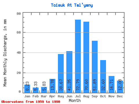
| Statistic | Jan | Feb | Mar | Apr | May | Jun | Jul | Aug | Sep | Oct | Nov | Dec | Annual |
|---|---|---|---|---|---|---|---|---|---|---|---|---|---|
| Mean | 8.23 | 5.38 | 5.83 | 13.78 | 38.67 | 41.35 | 72.78 | 70.59 | 51.89 | 32.59 | 16.71 | 12.08 | 369.64 |
| Standard Deviation | 2.46 | 1.81 | 1.86 | 5.00 | 11.73 | 17.69 | 32.18 | 27.10 | 19.30 | 10.12 | 4.08 | 2.88 | 85.28 |
| Min | 4.30 | 1.92 | 1.20 | 4.07 | 17.72 | 18.17 | 35.79 | 32.79 | 23.35 | 14.74 | 10.08 | 7.78 | 225.74 |
| Max | 13.94 | 9.69 | 9.56 | 26.40 | 58.06 | 80.18 | 154.17 | 151.67 | 95.20 | 54.81 | 26.65 | 17.95 | 529.78 |
| Coefficient of Variation | 0.30 | 0.34 | 0.32 | 0.36 | 0.30 | 0.43 | 0.44 | 0.38 | 0.37 | 0.31 | 0.24 | 0.24 | 0.23 |
 Return to R-Arctic Net Home Page