|
|
|||||||||||||||||
| Point ID: 6465 | Downloads | Plots | Site Data | Code: 8145 |
|
|
|||||||||||||||||
| Download | |
|---|---|
| Site Descriptor Information | Site Time Series Data |
| Link to all available data | |
| View: | Time Series | All |
| Units: | m3/s |
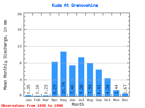
| Statistic | Jan | Feb | Mar | Apr | May | Jun | Jul | Aug | Sep | Oct | Nov | Dec | Annual |
|---|---|---|---|---|---|---|---|---|---|---|---|---|---|
| Mean | 0.35 | 0.17 | 0.23 | 8.29 | 10.74 | 7.40 | 9.38 | 7.93 | 6.41 | 4.34 | 1.44 | 0.67 | 60.83 |
| Standard Deviation | 0.35 | 0.19 | 0.27 | 4.94 | 5.92 | 6.55 | 7.64 | 6.07 | 4.21 | 2.04 | 0.75 | 0.57 | 24.02 |
| Min | 0.00 | 0.00 | 0.00 | 1.99 | 3.89 | 2.52 | 1.97 | 1.60 | 1.10 | 1.14 | 0.33 | 0.09 | 29.83 |
| Max | 1.31 | 0.76 | 1.30 | 27.38 | 30.78 | 44.96 | 34.50 | 37.23 | 21.23 | 9.60 | 3.31 | 2.99 | 159.13 |
| Coefficient of Variation | 0.99 | 1.14 | 1.19 | 0.59 | 0.55 | 0.89 | 0.81 | 0.77 | 0.66 | 0.47 | 0.52 | 0.85 | 0.40 |
 Return to R-Arctic Net Home Page