|
|
|||||||||||||||||
| Point ID: 6456 | Downloads | Plots | Site Data | Code: 8030 |
|
|
|||||||||||||||||
| Download | |
|---|---|
| Site Descriptor Information | Site Time Series Data |
| Link to all available data | |
| View: | Time Series | All |
| Units: | m3/s |
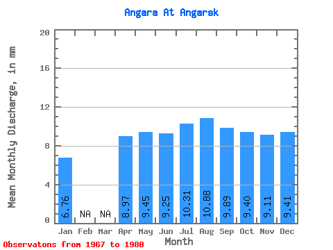
| Statistic | Jan | Feb | Mar | Apr | May | Jun | Jul | Aug | Sep | Oct | Nov | Dec | Annual |
|---|---|---|---|---|---|---|---|---|---|---|---|---|---|
| Mean | 6.76 | 8.97 | 9.45 | 9.25 | 10.31 | 10.88 | 9.89 | 9.40 | 9.11 | 9.41 | |||
| Standard Deviation | 2.25 | 1.32 | 1.19 | 1.79 | 2.83 | 3.04 | 2.29 | 2.47 | 2.41 | ||||
| Min | 6.76 | 7.67 | 6.63 | 7.33 | 8.20 | 8.64 | 6.80 | 6.67 | 5.38 | 5.55 | |||
| Max | 6.76 | 11.57 | 11.46 | 11.18 | 14.42 | 17.20 | 17.08 | 13.97 | 12.57 | 12.54 | |||
| Coefficient of Variation | 0.25 | 0.14 | 0.13 | 0.17 | 0.26 | 0.31 | 0.24 | 0.27 | 0.26 |
 Return to R-Arctic Net Home Page