|
|
|||||||||||||||||
| Point ID: 6451 | Downloads | Plots | Site Data | Code: 7190 |
|
|
|||||||||||||||||
| Download | |
|---|---|
| Site Descriptor Information | Site Time Series Data |
| Link to all available data | |
| View: | Time Series | All |
| Units: | m3/s |
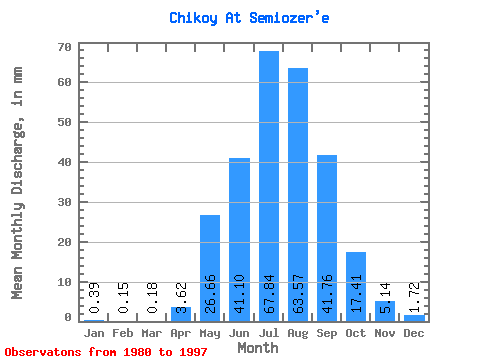
| Statistic | Jan | Feb | Mar | Apr | May | Jun | Jul | Aug | Sep | Oct | Nov | Dec | Annual |
|---|---|---|---|---|---|---|---|---|---|---|---|---|---|
| Mean | 0.39 | 0.15 | 0.17 | 3.62 | 26.66 | 41.10 | 67.83 | 63.56 | 41.76 | 17.41 | 5.14 | 1.72 | 271.18 |
| Standard Deviation | 0.25 | 0.17 | 0.24 | 3.84 | 10.52 | 23.97 | 32.99 | 22.69 | 23.11 | 8.80 | 2.42 | 0.91 | 78.61 |
| Min | 0.02 | 0.00 | 0.00 | 0.24 | 13.66 | 9.68 | 18.09 | 25.18 | 7.72 | 3.65 | 0.28 | 0.00 | 161.70 |
| Max | 0.89 | 0.71 | 0.74 | 13.15 | 42.74 | 114.15 | 122.73 | 113.15 | 106.25 | 37.24 | 9.32 | 3.09 | 452.11 |
| Coefficient of Variation | 0.63 | 1.11 | 1.39 | 1.06 | 0.40 | 0.58 | 0.49 | 0.36 | 0.55 | 0.51 | 0.47 | 0.53 | 0.29 |
 Return to R-Arctic Net Home Page