|
|
|||||||||||||||||
| Point ID: 6450 | Downloads | Plots | Site Data | Code: 7185 |
|
|
|||||||||||||||||
| Download | |
|---|---|
| Site Descriptor Information | Site Time Series Data |
| Link to all available data | |
| View: | Time Series | All |
| Units: | m3/s |
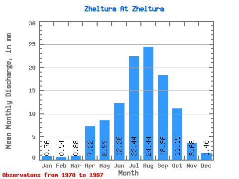
| Statistic | Jan | Feb | Mar | Apr | May | Jun | Jul | Aug | Sep | Oct | Nov | Dec | Annual |
|---|---|---|---|---|---|---|---|---|---|---|---|---|---|
| Mean | 0.76 | 0.54 | 0.88 | 7.22 | 8.59 | 12.28 | 22.44 | 24.44 | 18.39 | 11.14 | 3.68 | 1.46 | 116.06 |
| Standard Deviation | 0.50 | 0.39 | 0.71 | 4.20 | 4.17 | 9.62 | 14.11 | 16.28 | 11.68 | 5.17 | 2.00 | 0.91 | 48.64 |
| Min | 0.08 | 0.03 | 0.08 | 2.77 | 2.91 | 3.21 | 6.38 | 7.48 | 6.08 | 3.88 | 0.22 | 0.02 | 42.74 |
| Max | 1.75 | 1.36 | 2.45 | 17.31 | 18.67 | 32.55 | 51.05 | 71.66 | 45.01 | 20.97 | 7.19 | 3.16 | 199.92 |
| Coefficient of Variation | 0.66 | 0.71 | 0.81 | 0.58 | 0.49 | 0.78 | 0.63 | 0.67 | 0.64 | 0.46 | 0.54 | 0.62 | 0.42 |
 Return to R-Arctic Net Home Page