|
|
|||||||||||||||||
| Point ID: 6447 | Downloads | Plots | Site Data | Code: 7148 |
|
|
|||||||||||||||||
| Download | |
|---|---|
| Site Descriptor Information | Site Time Series Data |
| Link to all available data | |
| View: | Time Series | All |
| Units: | m3/s |
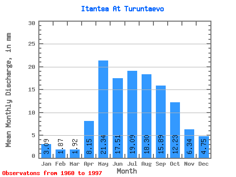
| Statistic | Jan | Feb | Mar | Apr | May | Jun | Jul | Aug | Sep | Oct | Nov | Dec | Annual |
|---|---|---|---|---|---|---|---|---|---|---|---|---|---|
| Mean | 3.08 | 1.88 | 1.92 | 8.15 | 21.34 | 17.52 | 19.09 | 18.30 | 15.89 | 12.23 | 6.34 | 4.75 | 129.79 |
| Standard Deviation | 1.38 | 0.95 | 0.95 | 2.65 | 7.70 | 7.10 | 9.23 | 8.09 | 7.35 | 5.73 | 2.56 | 1.67 | 38.87 |
| Min | 0.98 | 0.24 | 0.37 | 4.61 | 10.07 | 7.17 | 6.06 | 6.23 | 5.87 | 4.54 | 2.59 | 1.73 | 61.17 |
| Max | 6.29 | 3.57 | 3.47 | 16.26 | 53.05 | 33.01 | 39.29 | 37.52 | 39.00 | 32.46 | 13.69 | 8.86 | 195.82 |
| Coefficient of Variation | 0.45 | 0.51 | 0.50 | 0.33 | 0.36 | 0.41 | 0.48 | 0.44 | 0.46 | 0.47 | 0.40 | 0.35 | 0.30 |
 Return to R-Arctic Net Home Page