|
|
|||||||||||||||||
| Point ID: 6446 | Downloads | Plots | Site Data | Code: 7144 |
|
|
|||||||||||||||||
| Download | |
|---|---|
| Site Descriptor Information | Site Time Series Data |
| Link to all available data | |
| View: | Time Series | All |
| Units: | m3/s |
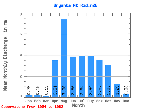
| Statistic | Jan | Feb | Mar | Apr | May | Jun | Jul | Aug | Sep | Oct | Nov | Dec | Annual |
|---|---|---|---|---|---|---|---|---|---|---|---|---|---|
| Mean | 0.25 | 0.18 | 0.13 | 3.51 | 7.38 | 3.86 | 3.94 | 3.94 | 3.57 | 3.07 | 1.29 | 0.33 | 26.77 |
| Standard Deviation | 0.24 | 0.19 | 0.12 | 1.90 | 4.21 | 1.72 | 2.50 | 1.77 | 1.53 | 1.18 | 0.58 | 0.27 | |
| Min | 0.05 | 0.04 | 0.01 | 0.12 | 2.67 | 1.47 | 1.53 | 1.57 | 1.45 | 1.31 | 0.32 | 0.05 | 26.77 |
| Max | 0.61 | 0.32 | 0.35 | 9.31 | 24.53 | 8.78 | 14.43 | 8.03 | 6.89 | 5.60 | 3.04 | 0.97 | 26.77 |
| Coefficient of Variation | 0.98 | 1.08 | 0.94 | 0.54 | 0.57 | 0.44 | 0.63 | 0.45 | 0.43 | 0.39 | 0.45 | 0.81 |
 Return to R-Arctic Net Home Page